Jersey Geology Trail |
|
Offshore Geology. Sea Floor. |
|
 |
|
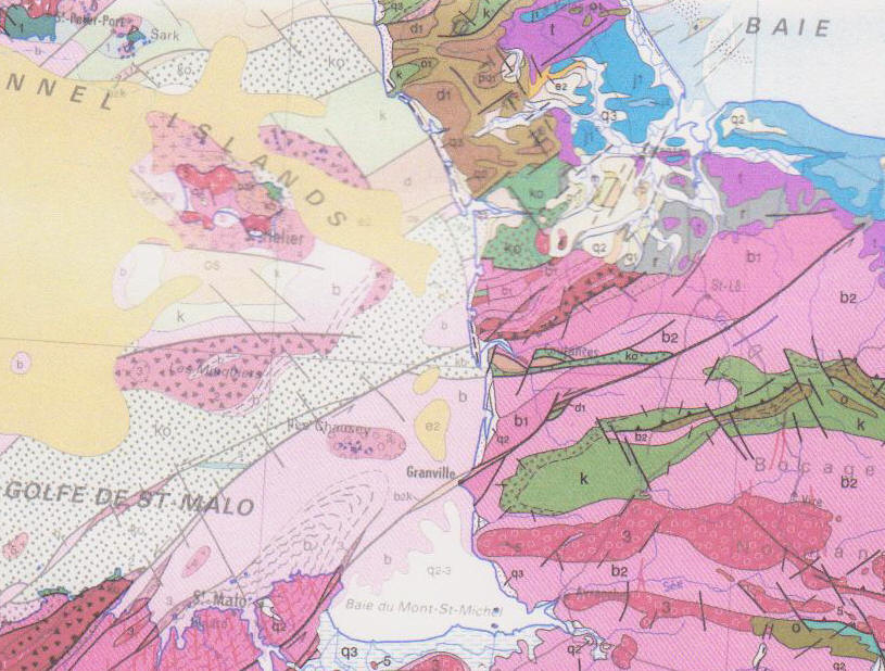
Sea floor geology around Jersey; pink (Precamb. shales); pale green & brown (Pal. seds.); red (L. Pal. granites, diorites); yellow (Tert. limestones). |
|
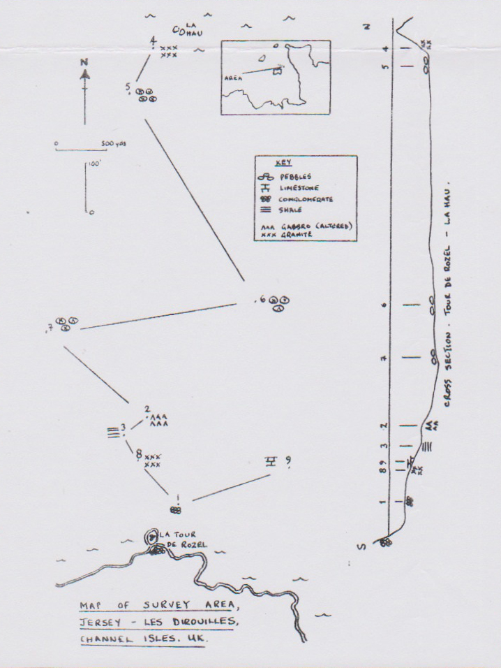
Jersey offshore geology sites add more interest to those of Jersey. The rock formations making up sea floor are taken from two maps. The first was produced from the joint work of geologists in British and French Universities and from the Institute of Geological Sciences and Le Bureau des Recherches Géologiques et Minières (BRGM) and published by The Institute of Geological Sciences as Guernsey Sheet 49N 04W. Solid Edition, 1:250 000 Series, 1976. The second is La Carte Géologique de la France, 1:1,000,000, 7th edition, 2003, compiled by geologists of Le Service Géologique National, and Le Comité Scientifique comprising directors of the Service and professors from the Universities and Institutes of the representative regions of the map. The most striking aspect of Jersey geology is that Jersey (and the other islands) are inliers or "windows" of older rocks almost surrounded by Tertiary (Eocene) carbonate rocks, the older rocks being largely Precambrian. However, the maps show sea floor Cambrian, Ordovician-Silurian and Devonian rocks in down-faulted association to the southeast of Guernsey and to the south of Jersey, and facies of Devonian rocks between the islands and the adjacent northern and central parts of the Cotentin coast. The Jersey offshore geology described below from maps, texts and visits, illustrates the gross lithologies and their ages clockwise around the island from the oldest rocks of the Jersey Shale Formation extending west from St. Ouën's Bay on Jersey's west coast West of Jersey, a small outcrop of Cambrian rocks is shown down-faulted to the west against the Jersey Shale Formation by a NW-SE striking fault, c.7km (4m) offshore. Within a short distance it is overlain unconformably by an extensive cover of Eocene (Lutetian) limestone which extends far to the west but also to the north then eastwards around Jersey. Northwest of the Jersey Shale Formation the rocks are those of the Northwest Igneous Complex, and this granite and gabbro/diorite complex extends northwest offshore towards Guernsey, labelled as Ordovician Granite (Guernsey Sheet, 1976) and includes metamorphosed granite of Vendian (Proterozoic) age affected by the Cadomian Orogeny, exposed in the reefs and stacks of Les Pierres de Lecq (Pater Nosters). North and north eastwards, this complex too is overlain unconformably by the eastern extension of the Tertiary limestone cover which divides into two "arms". The southern one extends southeast along Le Ruau Channel north east of Jersey where it lies on another mass of metamorphosed Vendian granite and Cambrian rocks cropping out to form the offshore reefs and islands of Les Dirouilles and Les Écréhous* {The northern lobate arm extends north and east covering Cambro-Ordovician rocks and Cambrian rocks.} * Les Écréhous rocks were described as a 'gneiss granulitique' in all three groups of islands (Noury, 1892, p.77 - 88) and more recently described as a foliated granodiorite (Renouf & Andrews, 1990. p. 20). They also describe and illustrate the geology and structure in fine detail. Along the north coast, the next rocks east of the NW Igneous Complex are those of the Jersey Volcanic Group and the Rozel Conglomerate Formation. These extend but a short distance offshore, c.3km (2m) before they too are overlain by the south eastern arm of the Tertiary (Eocene) limestone in Le Ruau Channel. This southern arm of these Eocene limestones has been examined in part by two geologists of the Jersey Sub-Aqua Club at sites 40m deep, 5km (3miles) north of La Tour de Rozel. The results of the survey indicate that the Rozel Conglomerate, Jersey Shale, and altered gabbro and granite rock types, similarly jointed and bedded to those on land, also occur as bedrock offshore; the contacts between them were covered by superficial deposits of pebbles and gravels of the same rock types (see map). Larger, rounded pebbles occur in the deeper parts (30 - 35m), possibly part of a former river bed. |
|
 |
|
Map of Les Dirouilles survey area. |
|
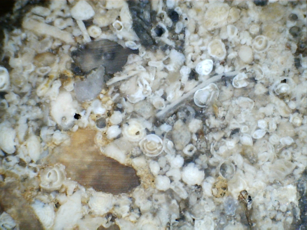
In addition, the first Tertiary deposits of foraminiferal limestone were found (see photo). They are Eocene in age (comparable to those of the Paris Basin, Dr. J. Murray, pers. comm.) and are poorly consolidated. The limestone outcrop contains cavities, gullies, channels and overhangs of variable size and depth, possibly due to solution and erosion. |
|
 |
|
Tertiary deposits of foraminiferal limestone. |
|
Information and reference to previous studies was summarised by A. E. Mourant (1965, p. 23;1966, p.114-115) who reported on the work of Boillot, Bignot & Hommeril, and Dangeard. Jersey geology to the east and south along Jersey's east coast, shows Jersey formations extending eastwards offshore into La Déroute Channel, where they too are shown to be overlain unconformably by the southern arm of the Tertiary limestone. Between Les Écréhous and the Normandy (Cotentin) coast, outcrops of Cambrian rocks faulted against Devonian rocks overlying a narrow outcrop of Ordovician-Silurian rocks southwards, are shown to be trough-faulted between outcrops of Cambro-Ordovician continental deposits of the Armorican Massif (cf. the Rozel Conglomerate Formation) occurring east of Sark* and to the east of La Rocque in Jersey (La Carte Géologique de la France, 1:1,000,000, BRGM, 2003, northern sheet) In some cases, these Palaeozoic outcrops seem to be western continuations of equivalents on the adjacent Cotentin coast, but in others they are shown to occur in a rift between the Cotentin and the older igneous rocks of Les Écréhous. *{NB. To the east and south-east of Sark, these Cambro-Ordovician continental deposits are shown as a continuation of the Devonian on the Guernsey Sheet, 1976.} Superficial deposits which had been collected along the line of the electricity cable between the Cotentin and Anne Port (Jersey), here form the bed of La Déroute channel, and were examined by members of the Geology Section of La Société Jersiaise. Unfortunately, no site positions were recorded but they consist of sand, grit, gravel and pebbles of the various Jersey rock types (but no limestones) and show a high degree of abrasion. Jersey geology around the south east corner consists of the Southeast Igneous Complex rocks, granites and diorites (La Rocque and Seymour Tower), but from there, ESE to Normandy, the sequence in the reefs is Mudstone cf. Jersey Shale (La Grande Anquette), Diorite gneiss, Granite gneiss (Les Boeuftins & Les Boeufs around La Chaussée des Boeufs) and Mudstone (Le Senequet, Normandy). This is recorded beautifully by A. E. Mourant and A. J. Robinson, 1938, p. 280-287). Jersey geology along its south coast consists of the granites and diorites mentioned above, the Jersey Shale Formation and the Southwest Igneous Complex (granites). NB. The two igneous complexes are shown to be continuous on both maps and extend southwards c.7km (4.5m) until outcrops of Ordovician-Silurian rocks (overlying Cambrian) are shown to be trough-faulted by E-W striking faults between them and more southerly Cambrian rocks (Guernsey Sheet, 1976)* These in turn overlie Brioverian (Precambrian) sedimentary rocks (cf. Jersey Shale Formation) to the south and west. All these rocks form a continuation of the "window" but consist of younger Lower Palaeozoic rocks lying between Jersey and the intrusive granodiorite of Chausey and the granite, gneiss and diorite of Les Minquiers. No lithogical symbols, eg. sandstone, limestone or shale are given for the Cambrian and Ordovician-Silurian rocks.{NB. La Carte Géologique de la France, 2003, shows an undisturbed Ordovician-Silurian to Brioverian sequence southwards, trough-faulted between Jersey and Les Minquiers, partly displaced by NW-SE striking faults}. |
|
 |
 |
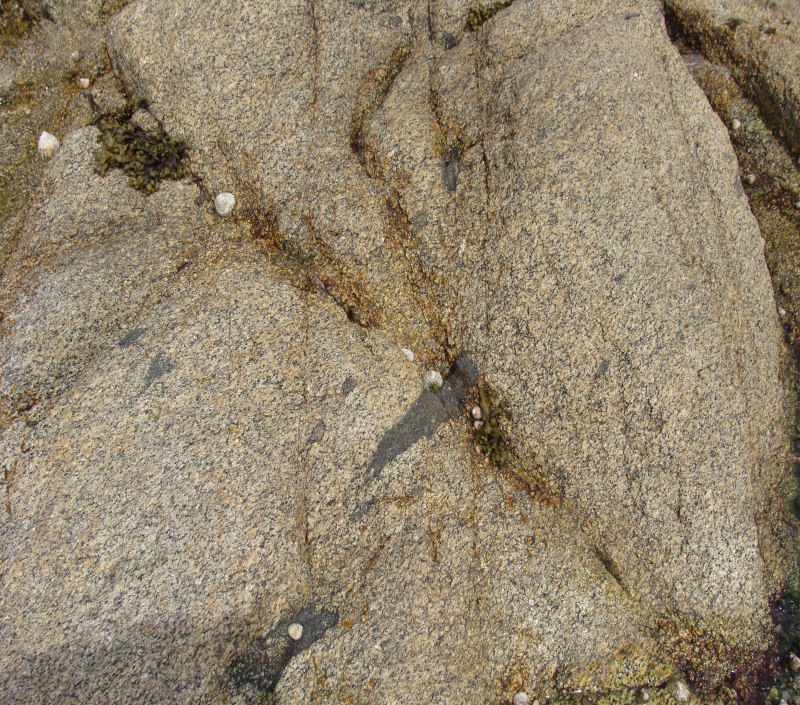
Granite, slightly foliated with basic xenoliths; weathered and eroded; Maîtresse Île, Les Minquiers. |
|
Les Minquiers geology is varied. The work of Graindor & Roblot in the Bull. of the French Geol. Soc, 1957 showed the rocks to be granitic, dioritic, migmatic, gneissic and banded on their map (in Robinson, 1959, p.218).The rocks of Le Petit Vasselin group were described as a foliated diorite and those of Les Maisons as a banded complex of foliated granite alternating with pegmatite and beautifully folded (Robinson, 1960, p. 292). Les Pipettes had been mapped c.20 years earlier as a granite gneiss which contained xenoliths of diorite gneiss which it had intruded, and the diorite gneiss which itself was full of xenoliths of a more basic rock; and "the finest known pegmatite in the Channel Islands consisting of large orthoclase crystals and coarsely saccharoidal quartz and containing garnets, muscovite and tourmaline" (Robinson, 1938, p. 285-286). Finally, south and southwest of La Corbière, these Precambrian, Cambrian and Ordovician rocks are again unconformably overlain by lobe-shaped outcrops of the ever-present Tertiary Eocene limestone deposits to the west. {Although not an off-shore sea-bed lithology around Jersey, Miocene limestones, known as Les Faluns, crop out 20 miles south of St. Malo preserved in an east - west striking rift valley. They are striking pale yellow varieties of detrital limestone, rich in echinoids and their spines, bivalve molluscs, coral and bryozoan remains, and even the ribs of Manatee (dugong). They are strongly cross bedded in parts and represent lagoonal sediments deposited in subtropical conditions, c.15 Ma ago. What caused the climate change!!!? The stone was quarried by the Romans to build a country villa estate just west of Le Quiou c.200AD and during the last 300 years was subsequently quarried for building stone, easily identified in the houses of the area. At present it is being crushed and used for fertiliser.} With reference to the flint pebbles in some of Jersey's raised beaches and on the present beaches, a probable source is represented by a small crescent shaped outcrop of Upper Cretaceous chalk overlying Devonian rocks, c. 12km (7m) southeast of Sark, while a larger outcrop unconformably overlies Precambrian and Lower Palaeozoic rocks about the same distance to the north and north east of Guernsey and Herm. These seem to be extensions of the widespread outcrops east of the Hurd Deep, underlying the Tertiary, and are the nearest to the islands. |
|
References. Institute of Geological Sciences. 1976. Guernsey Sheet 49N 04W, Solid Edition. 1:250, 000 Series. Institute of Geological Sciences. 1982. Classical areas of British geology. Jersey. Channel Islands Sheet 2, Solid and drift. Scale 1:25 000. Le Service Gélogique National. 2003. La Carte Géologique de la France, 1:1,000,000, 7th. édn. Mourant, A. E. 1965. Geology Section Annual Report for 1964. Ann. Bull. Soc. Jersiaise. Vol. 19, Pt. 1. p. 19. Mourant, A. E. 1966. Annual Geological Report for 1965. Ann. Bull. Soc. Jersiaise. Vol. 19, Pt. 2. p. 113. Noury, Ch. 1892. Roches des Écréhous, des Dirouilles et des Pierres de Lecq ou Pater-Noster. Description et Géologie. Bull. Soc. Jersiaise, Vol. 3, pp. 77 - 88. Patton. M. & Finlaison, M. 2001. Patterns in a Prehistoric Landscape. The Archaeology of St. Ouën's Bay, Jersey. Société Jersiaise. Renouf, J. T., & Andrews, M. 1996. Geology; in Les Écréhous, Rodwell, W. (Ed.), 1996. Société Jersiaise. Robinson, A. J. 1959. Geological Report for 1958. Bull. Soc. Jersiaise. Vol. 17. Pt. 3. Robinson, A. J. 1960. Geological Report for 1959. Bull. Soc. Jersiaise. Vol. 17. Pt. 4. Wyman, J. M. & Nichols, R. A H. 1971. Jersey Geology Survey. Sub - Aqua Magazine, Nov - Dec. p. 8 - 9. |
|