Jersey Geology Trail |
||
Folding. |
||
Folding in the Jersey Shale Formation outcrop, La Saline, St. Ouën's Bay. |
||
^N 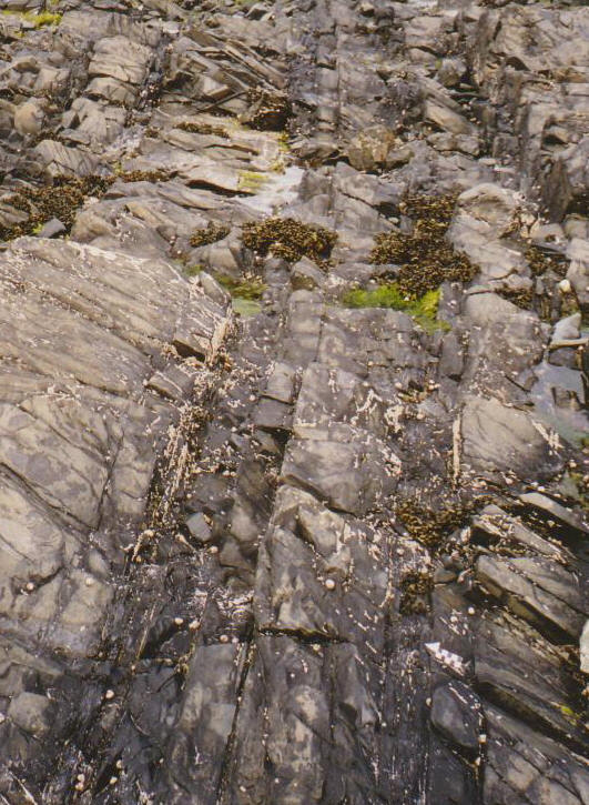 |
^S  |
^S  |
Jersey Shale, steep dip west, La Saline. |
Jersey Shale anticl.plunging south La Saline. |
Quartz 'saddle' veins indicating closure? La Saline. |
Folding is the process which causes rocks to be compressed laterally and uplifted into folds during an orogeny (mountain building period). These folds can be seen best of all in sedimentary rocks where the layers (beds /strata) occur in varieties of arch (anticline) and trough (syncline) structures with inclined (dipping) limbs. Their horizontal axes exhibit trends (strikes) in certain directions at right angles to the compression directions, and the dips of the limbs are also in directions at 90º to the axial strike. Other structural attitudes are periclinal, in the form of basins and domes. The varieties (styles) of fold describe the symmetry of the anticlines and synclines and are; symmetrical (limbs of equal dip), asymmetrical (limbs of unequal dip), monoclinal (one inclined limb), isoclinal (both limbs of parallel dip) and recumbent (overfolded). If folds are folded again during later orogenies, their axes can be refolded to dip into the earth and are then said to be plunging in a certain direction. In Jersey, the Jersey Shale, Volcanic and Rozel Conglomerate Formations have all been folded and the folds with all the measured dips are shown on the Jersey Channel Islands Sheet 2 (IGS, 1982) and described by Bishop & Bisson (1989, pp.72 - 76). |
||
 |
||
Map of the geological structure of Jersey. |
||
The easiest places to see the folded beds of the Jersey Shale Formation are in the northern parts of St. Ouën's Bay on the wave cut platform at L'Êtacq, at Le Pulec nearby (Bishop et al. 2003), in various quarries inland along La Route de la Vallée (St. Peter's Valley) and Le Mont Félard, and south of St. Aubin along the coast to Belcroute Bay (Nichols & Hill, 2004, p.29); this area also includes St. Aubin's Fort on an outcrop which can be walked around at low Spring tides. In these localities, one can see strata dipping both at shallow angles and nearly vertically, as parts of symmetrical folds, isoclines, plunging folds and as overturned beds. Bishop & Bisson (1989, p. 72 - 3), quoting the work of Squire (1974) and Helm (1983) describe the various folds and their sequence in detail and illustrate their axial trends and plunges. |
||
 |
||
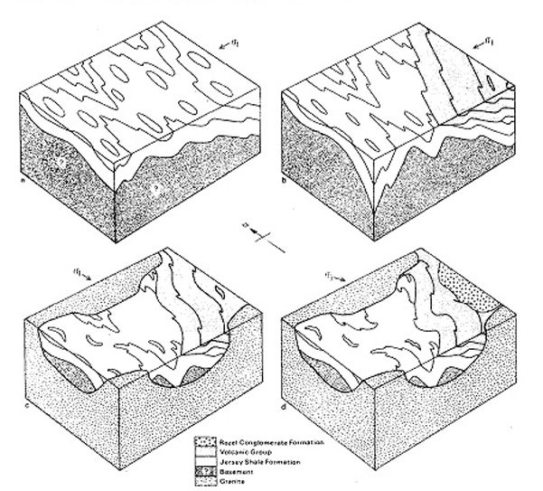
Helm's block diagrams showing the relationship between stress field, rock units andmajor structures at various periods during the tectonic evolution of Jersey. D1 late D1 D2 D4 |
||
Briefly, an initial period of folding (D1) produced N - S striking synclines (eg. St. Peter's) and complementary anticlines with their limbs dipping about easterly and westerly directions (due to E - W compression); this produced vertical bedded isoclines (Nichols & Hill, 2004, p. 97). A second period of folding (D2) with N - S compression produced generally E - W striking folds. Variation from a NW - SE strike at Le Pulec through N - S to NE - SW southwards along St. Ouën's Bay indicates an anticline (the St. Ouën Anticline) across the strike of the D1 folds. This N - S compression caused the original N - S axes (D1) to plunge generally north and south (Nichols & Hill, 2004, p. 96) respectively on each limb of the E - W folds (D2), and to produce asymmetrical periclines (domes). Similar variation of dip amount and strike direction can be seen in the St. Peter's Valley quarries (relatively shallow), Le Mont Félard (nearly vertical) and St. Aubin to Belcroute Bay (steep and nearly vertical) . The orogenic phases producing these folds have been dated as Cadomian, that is late Precambrian (Upper Proterozoic c.700-500 Ma) which apart from the above folds, have produced an overall dip to the east towards the overlying volcanic formations. The Jersey Volcanic Formations lie disconformably (with no angular unconformity) on the Jersey Shale Formation in La Belle Hougue area between Giffard Bay and Vicard Point, with a period of erosion marked by the thick breccio-conglomerate described by Helm (1984) and by Bishop & Bisson (1989, pp. 14 - 16); the latter however, conclude general conformity between the formations due to similar dips and strikes. Nevertheless, it would appear that the vulcanism was terrestrial and the various breccias/agglomerates contain fragments of the Jersey Shale Formation, suggesting orogenic uplift and folding prior to volcanic activity. The similarity in structural attitude may be a result of later accommodation to posthumous control. In the Jersey Volcanic Formation, three fold strike directions are recorded, striking NE - SW, N - S and E - W. These all represent plunging folds but with different plunge directions. The first two, like the main Trinity Syncline, plunge in a NE direction with various other folds plunging to the NNE and N. On the other hand, the outlier of the St. Helier Syncline which also strikes NE - SW, plunges to the SW and is separated from the north easterly plunging ones by refolded W - E plunging anticlines and synclines in the underlying Jersey Shale Formation (Bishop & Bisson, 1989, p. 75). The third strike direction is the generally E - W striking St. Saviour's Anticline which is illustrated folding the andesites and plunging eastwards towards the east coast. |
||
 |
||
The overlying Rozel Conglomerate Formation rests on the folded erosional surface of both the Middle and Lower Bouley Ignimbrite of the upper rhyolite unit (the Bouley Rhyolite Formation) of the volcanic terrain (Renouf in Bishop & Bisson, 1989. p. 42). In general, the fold strikes and plunges are similar to those in the volcanics. However, a major syncline, the Rozel Syncline, striking WNW - ESE is similar to that of the folded unconformity and represents a post conglomerate D3 period of folding with approximately N - S compression. A possible example of the style of folding (anticline above) is exposed in the outcrops to the south of the harbour; the strike is c. SE - NW, although the bed overlying the crest and the wedge-shaped bed on the left flank seem to indicate a local unconformity. The sinuous strike suggests more folding about NE - SW axes but may only represent accommodation to the underlying folds. Given that the volcanic rocks and conglomerates are thought to be of Lower Palaeozoic age might not these rocks have been subject to later Palaeozoic orogenies with compression from the NW - SE and N - S respectively, eg. Caledonian (though considered too far to the north by some authors) and Hercynian. Alternatively, the Cadomian fold strikes (N - S and E - W) could have posthumously affected later Palaeozoic folding to produce those similar fold strikes in the volcanics and conglomerates. |
||
References. Bishop, A. C. and Bisson, G. 1989. Classical areas of British geology: Jersey: description of 1:25,000 Channel Islands Sheet 2. (London: HMSO for British Geological Survey). Bishop, A. C., Keen, D. H., Salmon, S. and Renouf, J. T. 2003. Geology of Jersey, Channel Islands. Geologists' Association Guide No. 41. Casimir, M. 1934. Studies in folding of the Jersey Shales. Proc. Geol. Ass. Vol. 45. pp. 162 -166. Helm, D. G. 1983. The structure and tectonic evolution of the Jersey Shale Formation. Proc. Geol. Assoc. Vol. 94. pp. 201 - 216. Helm, D. G. 1984. The tectonic evolution of Jersey, Channel Islands. Proc. Geol. Assoc. Vol. 95. pp. 1 - 15. Mourant, A. E. 1933. The geology of eastern Jersey. Q. J. Geol. Soc. London. Vol. 89. pp. 273 - 307. Nichols, R. A. H. and Hill, A. E. 2004. Jersey Geology Trail. Private publication; printed by The Charlesworth Group. Squire, A. D. 1974. Brioverian sedimentology and structure of Jersey and adjacent areas. Unpublished PhD thesis. University of London. |
||