Jersey Geology Trail |
|||||||||||||||||||||||||||||||||||||||||||||||||||||
Jersey Geology Trail ....Water, Fire and Ice. |
|||||||||||||||||||||||||||||||||||||||||||||||||||||
 |
|||||||||||||||||||||||||||||||||||||||||||||||||||||
NW granite at Plémont. |
|||||||||||||||||||||||||||||||||||||||||||||||||||||
There are many beautiful scenic localities along the trail, with excellent exposures showing a variety of colourful rock types, structures and textures which illustrate the way Jersey has evolved through changes from a marine deltaic environment to one of mountains and volcanoes, to an arid desert with flash floods and finally to a periglacial area in the path of loess-laden winds, when it changed from a hill on a coastal plain to an island as the sea levels and climate changed. These sites can be explored individually during a morning or afternoon walk and the majority are beach traverses. Therefore, extra caution must be taken to check the times of high low tide, with the best time for a walk being at the start of a falling tide. Remember also to be very, very careful when examining cliff sections and quarries, and to wear appropriate clothing for the weather and the terrain. The following localities are presented in a sequence which will illustrate Jersey's geological history from the oldest to youngest rocks, thus allowing you to walk through time and see the environments which existed in times past and which reveal how Jersey was formed. All the rock types and their features are described more fully on the relevant pages of the website and by Bishop & Bisson (1989), Bishop et al (2003) and Nichols & Hill (2004). The Jersey Shale Formation (c. 660 - 540Ma) |
|||||||||||||||||||||||||||||||||||||||||||||||||||||
 |
|||||||||||||||||||||||||||||||||||||||||||||||||||||
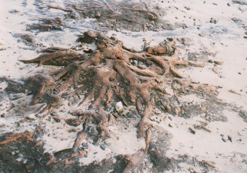
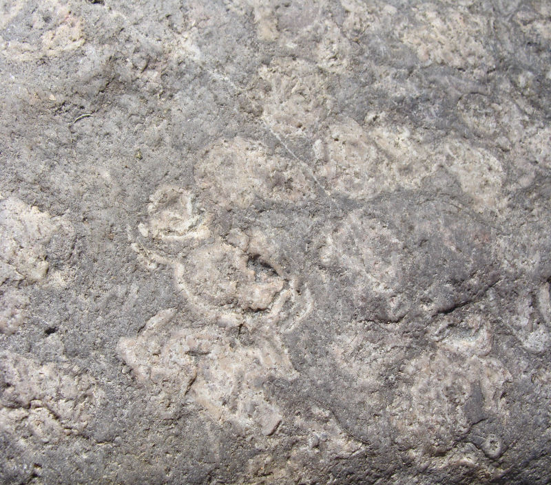
These rocks are of late Precambrian age, seemingly unfossiliferous, and are the oldest rocks in the island. They formed part of a submarine deltaic area adjacent to areas of high land with intervening basins along the NW margins of the Armorican continent to the south. They are well exposed at several localities and consist of grey shales, greywackes and siltstones and several intraformational conglomerates. They are excellently exposed in the beach area around L'Étacq and in Le Pulec, an inlet immediately north of the small harbour, at the northern end of St. Ouën's Bay Around L'Étacq, they form part of a wave cut platform so the folds and faults, laminated, graded and often ripple-laminated beds and sedimentary boudinage can be easily seen (Nichols & Hill, 2004. pp. 95,97). In Le Pulec, similar features can be seen as well as contact metamorphic textures, dykes and mineral veins showing the intrusive relationships with the pink, coarsely crystalline granite of the NW Igneous Complex. {To avoid a return visit to the bay for a strictly stratigraphic trail, you can also spend time exploring the Recent Superficial Deposits forming the sand dunes with their thin peat beds which have formed along the fossil cliff line at the back of the bay; and if you are lucky, the peat beds and remains of the submerged forest near La Saline, L'Ouzière and Le Port slipways may also be exposed.} |
|||||||||||||||||||||||||||||||||||||||||||||||||||||
 |
 |
||||||||||||||||||||||||||||||||||||||||||||||||||||
Another trail where you can explore the Jersey Shale Formation is along the beach and a path cut into the rocks from St. Aubin's Harbour southwards to Belcroute Bay. Here, the formation is exposed in the relatively narrow coastal outcrop, again steeply dipping, but here intruded by dolerite, mica lamprophyre and rhyolite in the form of dykes, some of which are tear faulted. The junction with the SW Igneous Complex is hidden below beach gravels but nearby exposures reveal some of its nature (Nichols & Hill, 2004. p.36). {Again, as with St. Ouën's Bay you can also examine the Superficial Deposits which form cliffs of varying heights along the trail but here they include raised beach deposits of gravels and glacial head and loess (Bishop et al. 2003. p. 21).} A certain amount of folding from several directions then occurred, related to pulses in the Cadomian Orogeny, to produce the striking dips and folds seen in the St. Ouën's Bay wave-cut platforms because these volcanic formations overlie the Jersey Shale Formation disconformably in parts with no great divergence of dips; but the disconformity possibly represents a long time interval of erosion where a breccio-conglomerate occurs (Bishop & Bisson, 1989, p.16); they are all dated as equal to or older than 533Ma. which implies that they are Cambrian in age. The volcanic rocks extend in an arc-shaped outcrop between the central parts of the northern and eastern coasts and the various deposits represent a change to sub-aerial, extrusive volcanic activity in the late Precambrian or Cambrian (op. cit. p.13). The St. Saviour's Andesite Formation now occurs in two plunging synclines striking approximately northeast and southwest while the two rhyolite formations only occur in the northeast plunging syncline. St. Saviour's Andesite, St. John's Rhyolite & Bouley Rhyolite Formations (c. >533 Ma)The St. Saviour's Andesite Formation.The St. Saviour's Andesite Formation is the lowest of the three and lies disconformably on the Jersey Shale Formation. It occurs in three main areas - east and west of La Belle Hougue Point on the north coast, in the northeast plunging Trinity Syncline at various places inland as far east as Gorey, and on the south coast just west of St. Helier around the bathing pool (Victoria Marine Lake) where scattered outcrops form part of the southwest plunging St. Helier Syncline. Each locality reveals the variety of rock types making up the andesite formation. They range from andesites, to tuffs and agglomerates of andesitic and basaltic composition. *****Great care must be taken in the cliff areas of the headland and about the high and low tide times in the bays. In outcrops west and east of La Belle Hougue Point andesites, tuffs and agglomerates overlie a breccio-conglomerate containing Jersey Shale Formation clasts, exposed at the eastern end of a beach walk along Giffard Bay. Excellent descriptions of this area occur in Bishop et al (2003. pp. 41 - 44). Access to the other rocks is better via the several paths on La Belle Hougue headland, and andesite can be seen if you descend into Le Petit Port cove via La Rue d' Égypte while tuffs are exposed at Vicard Point further east. Along the traverse you will also see outcrops of granite and diorite which have intruded the andesite sequence and L'Homme Mort Conglomerate which seems unrelated to the other conglomerates in Jersey and has been given a separate rock unit name (Bishop & Bisson, 1989. p.3). The St. John's Rhyolite and Bouley Rhyolite Formations. |
|||||||||||||||||||||||||||||||||||||||||||||||||||||
 |
|||||||||||||||||||||||||||||||||||||||||||||||||||||
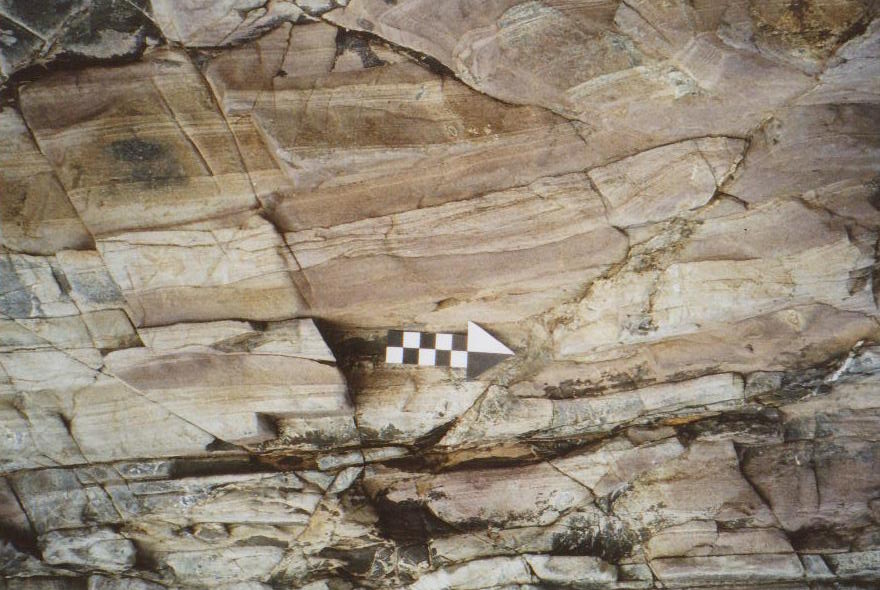
These formations can also be explored on this traverse and they extend from St. John's Bay on the north coast to just south of Anne Port Bay on the east coast and are exposed in fine coastal sections. In general, the St. John's Rhyolite overlies the St. Saviour's Andesite unconcoformably with interformational mudstones and conglomerates on the north coast and actually consists of five massive acid ignimbrite units each with several individual flows while the overlying Bouley Rhyolite Formation starts with an agglomerate and then comprises rhyolite flows followed by thin andesites (see stratigraphic table below). They exhibit a fine variety off textures and structures which include pyroclastic, eutaxitic ('streaky bacon'), fiamme (collapsed pumice), tuffaceous, flow banded, spherulitic, columnar, and autobrecciation features. On the east coast, neither the St. Saviour's Andesite nor the base of the St. John's Rhyolite Formation are seen and the formation 'starts' with two ignimbrites exposed from Petit Portelet, a small cove immediately north of Mont Orgueil (where there is an intrusive contact with granite of the SE Igneous Complex) to Le Saut Geffroi (Jeffrey's Leap) and Anne Port. The rhyolite formations, with our own 'Giant's Causeway' at La Crête (Nichols & Hill, 2004, pp. 19 - 23), are then followed by ignimbrite and tuff formations northwards along the coast across the bay of Le Havre de Fer (which also contains outcrops of the columnar rhyolite) and part way across St. Catherine's Bay. Note too, that the dips are generally ENE on the north coast, with an overturned section at La Crête (north coast), but vary between N - NNW on the east coast (Bishop & Bisson, 1989, pp. 14, 24, 27), apparently producing folding about N - S and E - W axes in the NE plunging syncline. However, it seems difficult to determine how much of this is due to tectonics or angle of rest (on flanks). The following stratigraphic table of the units within each Formation has been compiled from the work of Bishop & Bisson (op. cit 1989) in order to present and permit comparisons between the two sequences. No correlations are implied and moreover, it might be considered improbable with the variations in time and space which generally occur in intermediate and acid eruptions. With the use of their IGS geology map, Classical areas of British Geology, Jersey, Channel Islands Sheet 2, 1:25 000, 1982, the successions can be followed as trails along each of the coasts. Note that the colours, structures and textures which aid identification of the units are fully described in the references (Bishop & Bisson, 1989; Bishop et al. 2003; Nichols & Hill, 2004). ***Great care must be taken in the cliff areas of the headland and about the high and low tide times in the bays. |
|||||||||||||||||||||||||||||||||||||||||||||||||||||
|
|||||||||||||||||||||||||||||||||||||||||||||||||||||
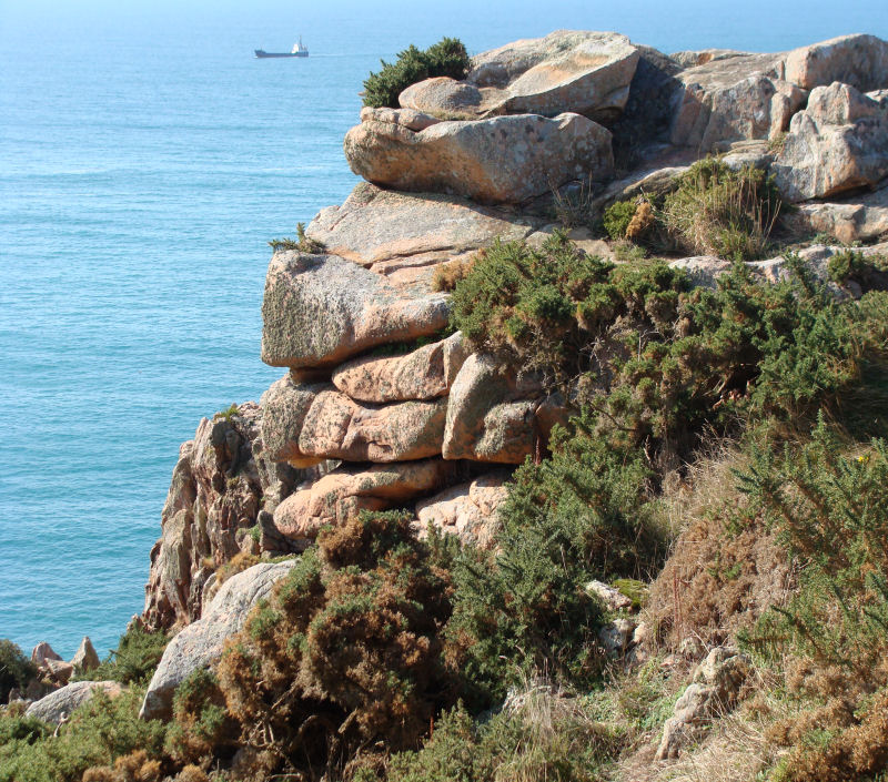
The Granite, Gabbro & Diorite plutons (c. 580 - 426Ma)Geologically, Jersey is probably best known from travel brochure descriptions of its striking pink granite cliffs and bays. However, less well known is the striking variety of different granites, gabbros and diorites within small complexes. Added to this is the variation in their ages and although superficially resembling the Cornish pattern of the bosses and stocks of an underlying batholith, they have quite different structural and petrological histories. There are three main masses which form the SW, NW and SE corners of the island and there are two or three possible trails in each area. Detailed descriptions of the complexes and their origins are given on the relevant web pages. |
|||||||||||||||||||||||||||||||||||||||||||||||||||||
 |
 |
||||||||||||||||||||||||||||||||||||||||||||||||||||
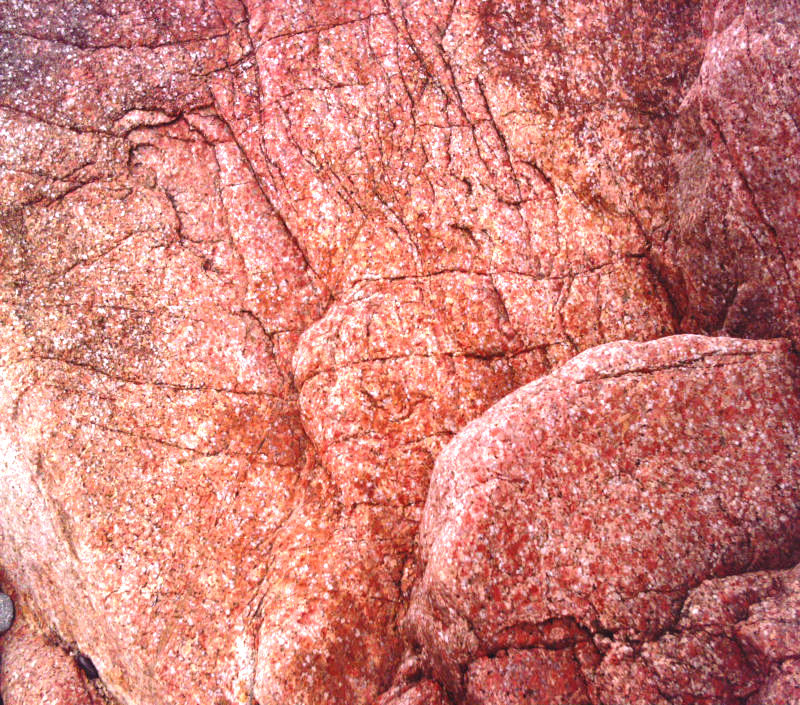
The SE granite (c. 580 - 509?Ma) consists of several different granites, most of which include gabbroic and dioritic sections and all of which exhibit excellent structures and textures ranging from porphyritic to xenolithic and with alteration and low grade metamorphic minerals. There seems to be no agreement on their ages, but the dates discussed suggest they were intruded from the late Precambrian possibly to the very early Ordovician. They crop out along the southern and south eastern coasts from the Fort Regent (Le Mont de la Ville ) area of St. Helier and Elizabeth Castle (the Ft. Regent/Elizabeth Castle granophyre) eastwards through Le Dicq (the Dicq granite with the Longueville granite inland), La Motte (Green Is.), Le Hocq, La Rocque (the La Rocque granite) and north to Mont Orgueil (Gorey). In this section, a dolerite dyke swarm is well exposed at Le Hocq. The SW granite (c. 550 - 483Ma) actually consists of three granites intruded at different times during the Cambro-Ordovician, in a concentric outcrop pattern open to the south. From Le Grouet slipway (just north of the famous lighthouse at La Corbière) and south across the rocks around the lighthouse causeway, then eastwards towards La Rosière, the outer pink Coarse Granite (c.483Ma) is well exposed and the individual crystals of quartz, feldspar and hornblende can be easily seen. Aplite dykes and veins are plentiful, along with rarer dolerite dykes, coarse patches of milky quartz and pink orthoclase, and someisolated magnetite patches, as one walks out onto the wave-cut platform where gullies have been eroded along the dykes, faults and master joints. |
|||||||||||||||||||||||||||||||||||||||||||||||||||||
 |
 |
||||||||||||||||||||||||||||||||||||||||||||||||||||
In Ouaisné Bay, the trail is shorter, from the slipway at Ouaisné across the beach to the foreshore outcrops with 'déviations' to the nearby fallen boulders and quarries. Here, you can examine the other two granites of the complex (as well as the Corbière one) and see their relationships more easily. The foreshore rocks consist of the red to orange, finely crystalline microgranite (aplite), the Beau Port granite (c.527Ma) which extends westwards across St. Brelade's Bay and forms the central granite of the complex, a red to pink porphyritic La Moye granite (c.550Ma) with porphyritic feldpars showing various growth stages in an aplite matrix which forms a narrow middle ring, as well as the coarse outer granite. Again, aplite and dolerite dykes are well exposed showing control by faults and joints permitting relative dating of events. The boulders reveal micropegmatite quartz and feldspar patches and relict patches (xenoliths) of diorite. |
|||||||||||||||||||||||||||||||||||||||||||||||||||||
 |
 |
||||||||||||||||||||||||||||||||||||||||||||||||||||
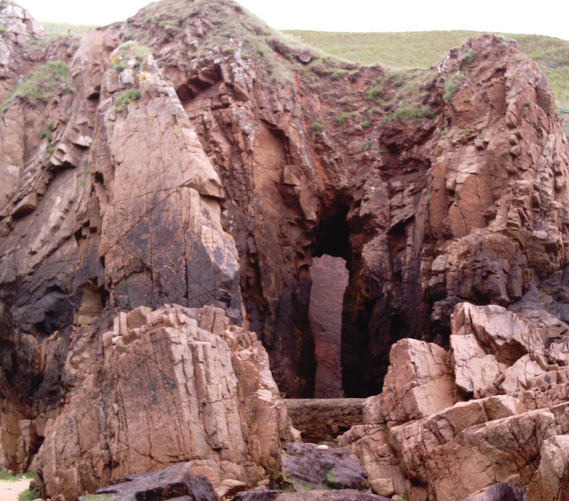
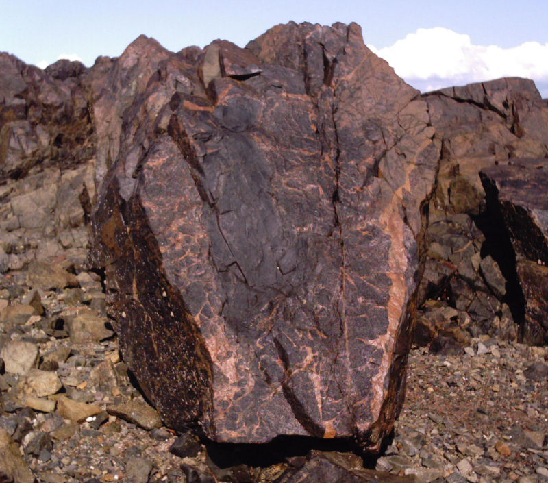
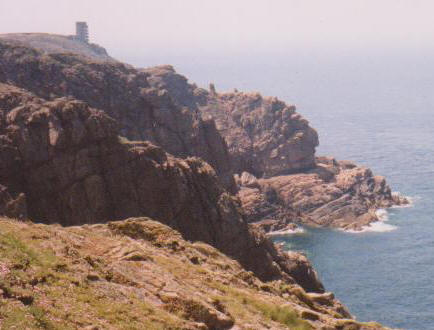
The NW granite (c. 465 - 426Ma) consists of four different granites which were also intruded at different times, but during the Ordovician - Silurian. One of them contains gabbros and they all crop out along the northwestern and northern coasts in concentric rings open to the north. The central one is a Biotite microgranite (no date given) around Le Rouge Nez Point just east of La Grève de Lecq, but this is difficult to access unless permission is obtained. Around this granite is a Porphyritic granite (465Ma) which is easily accessible and can be seen from La Grève au Lanchon (at Plémont) to La Grève de Lecq and east to Devil's Hole. Around this is an Outer Coarse granite (438Ma) which is well exposed and easily accessible from the quarries at L'Étacq and across Les Landes to Grosnez, and on Sorel Point in the east where it is strikingly mixed with gabbros and diorites. Finally, the fourth type, the Mont Mado granite (426Ma) is a striking red to brown and orange aplite found, not in the quarry any more, but in the walls around the Mont Mado area at the eastern end of the outcrop. The Rozel Conglomerate Formation (c. 533 - 427Ma). |
|||||||||||||||||||||||||||||||||||||||||||||||||||||
 |
|||||||||||||||||||||||||||||||||||||||||||||||||||||
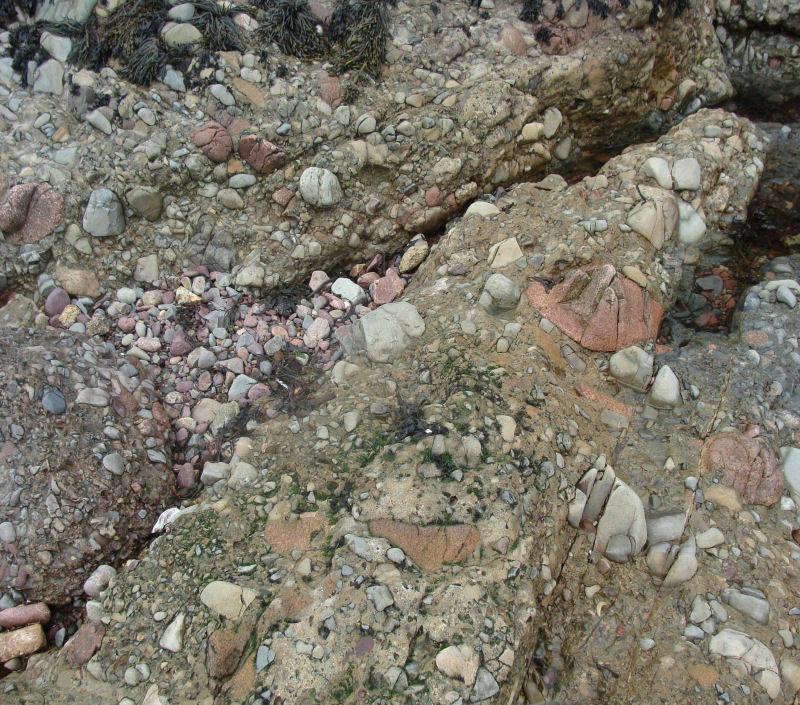
This formation overlies the volcanic formations and the main outcrop forms the north eastern corner of the island. It lies unconformably on the Bouley Rhyolite Formation and excellent exposures occur below La Tête des Hougues in Trinity on the north coast, in roadside cuttings by La Solitude Farm, and from Bel Val Cove towards St. Catherine's Breakwater, the last two being on the east coast in St. Martin. Briefly, the formation starts with basal 'red beds' of siltstones and sandstones overlain by poorly sorted, weakly bedded sometimes massively bedded pebble beds with pebbles of the local rocks except for the granite pebbles which unusually are from another source. It is dated between 533-427Ma which is from Ordovician to Silurian. The most spectacular exposure, below La Tête des Hougues is the most difficult of access and is approached down a fisherman's path from the North Coast Cliff Path ; Great care must be taken in the summer as high banks of fern surround this path. Once down on the beach, the unconformity between the rhyolite and the basal red sandstone, microconglomerate and siltsone beds can be examined. There is a nearby excellent vertical cliff exposure revealing the variety of size and shape of the overlying pebble beds (Renouf in Bishop & Bisson, 1989, p. 40; Bishop et al. 2003, p. 45; Nichols & Hill, 2004, p.77). The exposures in the road cuttings at La Solitude Farm reveal red, brown and grey fissile siltstones and interbedded pebble layers, all of which are crumbling but fallen samples reveal the variety. The Bel Val to St. Catherine's Breakwater exposure shows the same variety and is the easiest section. This part of the trail starts from just north of the slip-way into Bel Val Cove and is approached along the top of the sea wall from which one can descend onto the easily accessible, low rocky cliffs backing the beach. Along here, the pebbles show their full variety of rock types, colours, shapes, size, rounding and sorting (Nichols & Hill, 2004, p. 87). Interesting exposures also occur in the beach to the south of St. Catherine's Round Tower slipway and to the north of St Catherine's Breakwater towards Fliquet and La Coupe Point. Superficial deposits (raised beaches, glacial head, loess, peats, sands, gravels & clays). |
|||||||||||||||||||||||||||||||||||||||||||||||||||||
 |
 |
||||||||||||||||||||||||||||||||||||||||||||||||||||
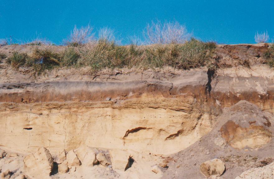
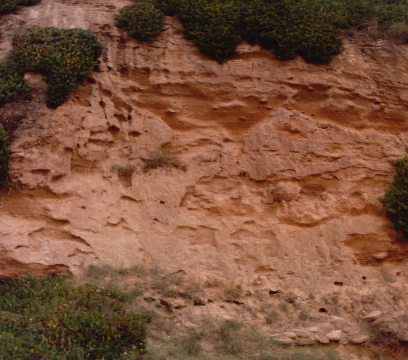
These are exposed at various places around the coasts and inland, eg. accessible raised beaches occur in the cliffs at Portelet (photo above) and just north of Belcroute; glacial head can be seen overlying most outcrops, eg. in Le Pulec; loess can be seen at La Motte (Green Is.); peat beds and gravels can be seen within the aeolian sand deposits of the excellent dune section in the southern part of St. Ouën's Bay (photo above) and a variety of different coloured silts and clays can be seen along the south coast lying in hollows on the eroded bedrock surfaces, St. Brelade's Bay to Seymour Tower. The latter appear and disappear, often with each tide, when they are covered by recent beach gravels. ***None of these should be collected and specimens cannot be taken from the island. |
|||||||||||||||||||||||||||||||||||||||||||||||||||||
|
|||||||||||||||||||||||||||||||||||||||||||||||||||||